
Out of Town Blog
Is the Philippines ready for the Big One?
The Big One: Assessing National Preparedness for a Major Earthquake
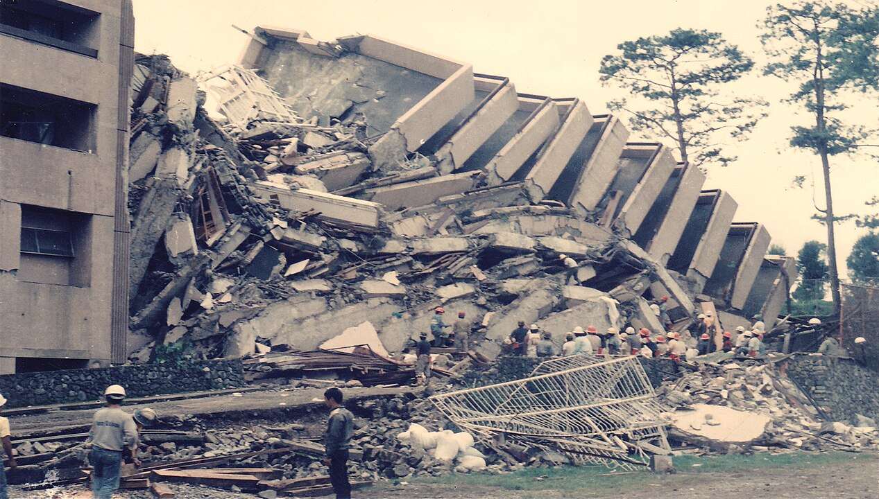
Situated along the volatile Pacific Ring of Fire, the Philippines faces frequent seismic activity that puts its densely populated cities at persistent risk. In particular, Metro Manila and its surrounding regions are threatened by the West Valley Fault, which scientists warn could generate a devastating 7.2-magnitude earthquake known as “The Big One.” If this quake were to occur, it could affect more than 100,000 residents, causing widespread destruction to residential neighborhoods, towering office buildings, roads, and vital facilities, which would complicate the challenge of rapid response and recovery.

Despite ongoing government efforts and scientific research, experts believe the Philippines is not fully prepared for The Big One, with significant gaps remaining in building safety, emergency response systems, and public awareness. The Office of Civil Defense has admitted the country still has much work to do across three key areas: engineering solutions, emergency response, and overall preparedness. Recent studies show that many buildings in Metro Manila would not survive such a powerful earthquake.
Understanding the risks, scientific research, and current state of preparedness can help Filipinos better grasp what needs to happen before this major earthquake strikes. The government continues working with international partners to update emergency plans and improve safety measures, but time may be running short as seismic activity in the region continues to build pressure along major fault lines.
Defining the ‘Big One’ and Its Implications
Earthquake Risk in the Philippines
Located on the Pacific Ring of Fire, thousands of earthquakes strike each year. Most are too minor to cause any damage, but larger quakes sometimes have devastating consequences for certain areas.
Key Risk Factors:
- Location on active tectonic plates
- Multiple fault lines across the archipelago
- Dense population in high-risk areas
- Older buildings not built to earthquake standards
The West Valley Fault runs directly through Metro Manila. This fault line poses the greatest threat to the most populated area of the country.
Scientists monitor seismic activity constantly. They use data to predict when major earthquakes might occur.
Expected Magnitude and Affected Areas
An earthquake known as “The Big One” is projected to cause severe damage to buildings and infrastructure. Metro Manila faces the highest risk, as it is situated directly above the West Valley Fault. Surrounding provinces would also experience strong shaking.
Expected Damage Areas:
- Metro Manila – Severe structural damage
- Cavite – Major infrastructure damage
- Laguna – Building collapses likely
- Rizal – Widespread property damage
The entire island of Luzon must prepare for this earthquake. Even areas far from the fault will feel strong tremors.
Government studies predict thousands of casualties. Many buildings may collapse completely. Roads, bridges, and utilities could fail across the region.
Historical Earthquakes
The West Valley Fault, traversing Metro Manila and nearby provinces, is a major fault line in the Philippines known for producing large earthquakes approximately every 400 to 600 years. The last significant fault movement was recorded in 1658, indicating that another major quake may be imminent. Given the fault’s location near highly populated areas, experts stress the need for seismic preparedness in Metro Manila and surrounding provinces.
Earthquakes are a frequent hazard in the Philippines due to its position on the Pacific Ring of Fire. Notably, the 1990 Luzon earthquake, with a magnitude of 7.8, struck northern and central Luzon on July 16, 1990. The quake caused severe destruction, left over 1,600 people dead, injured thousands, and damaged infrastructure, highlighting the country’s ongoing risk from major earthquakes and the need for readiness and resilience in affected regions.
Notable Philippine Earthquakes:
- 1990 Luzon – 7.8 magnitude, 1,600+ deaths
- 2013 Bohol – 7.2 magnitude, 200+ deaths
- 1976 Mindanao – 7.9 magnitude, 8,000+ deaths
Recent earthquakes in Myanmar and Thailand have reminded scientists of the ever-present risk of the Big One, illustrating how rapidly devastating quakes can strike without warning.
A 2004 study on the Big One’s potential impact will be reviewed in 2026, with Philippine and Japanese authorities planning to update their research and predictive models.
Understanding the West Valley Fault
The West Valley Fault is a major geological fault line in the Philippines, extending through Metro Manila and nearby provinces, including Bulacan, Rizal, Laguna, and Cavite. This fault is part of the Marikina Valley Fault System and is considered the most active fault in the region. Historical studies indicate that the West Valley Fault produces major earthquakes—known as “The Big One”—every 400 to 600 years, with the last major event occurring over 350 years ago. This periodic seismic activity poses significant risks to densely populated areas, threatening infrastructure, property, and the safety of millions of residents.
Fault Location and Length
The West Valley Fault runs along the eastern side of Metro Manila. It stretches through several key urban areas in the National Capital Region.
The fault extends from the Sierra Madre mountains down through populated cities. It passes through areas where millions of people live and work every day.
Scientists have mapped the fault’s path carefully. The fault line cuts through densely populated neighborhoods and business districts.
The West Valley Fault connects to other fault systems in the region. This makes it part of a larger network of geological features that can affect earthquake activity.
Cities and Provinces at Risk
Metro Manila faces the highest risk from West Valley Fault movement. The capital region sits directly on top of portions of the fault line.
Major cities at risk include:
- Quezon City
- Marikina
- Pasig
- Manila
- Makati
Surrounding provinces such as Rizal, Bulacan, and Laguna are also at risk and could experience significant tremors.
The fault impacts both urban and suburban communities, endangering millions of residents within its potential reach.
Risk levels vary between cities, largely depending on how close they are to the fault line, which determines the intensity of shaking they might experience.
Potential Consequences of Fault Movement
Potential impacts include:
- Over 50,000 possible deaths
- 168,000+ buildings could collapse
- Major infrastructure damage
- Economic disruption
An earthquake in this region would severely impact vital facilities such as hospitals, schools, and government establishments, many of which were built before strict seismic codes and are thus at risk of serious damage or collapse. The transportation network, including highways, local roads, bridges, and airports, could be rendered inoperable by extensive ground shaking, greatly hindering rescue and relief operations. Damage to runways and airport structures could ground flights and slow the delivery of vital aid.
Utility systems would also be hit hard: Water distribution lines, power grids, and gas supplies might be disrupted for extended periods, possibly lasting weeks or months. The resulting water and power shortages would pose significant challenges for daily life and make recovery efforts far more difficult for survivors and emergency responders alike.
Historical analysis of the fault line shows it has shifted four times in the last 1,400 years. The most recent of these major seismic events occurred around 1658. Given the amount of time since the last significant quake, the probability of another major earthquake in the near future is increasing.

Government Agencies and Scientific Research
Multiple government agencies work together to study and prepare for major earthquakes in the Philippines. PHIVOLCS leads earthquake monitoring efforts while collaborating with other departments to improve the country’s disaster readiness through modern technology and research partnerships.
Role of PHIVOLCS in Earthquake Monitoring
The Philippine Institute of Volcanology and Seismology (PHIVOLCS) serves as the country’s primary agency for earthquake research and monitoring. This agency operates under the Department of Science and Technology (DOST) and provides critical data about seismic activity.
PHIVOLCS conducts regular studies on fault lines across the country. The agency focuses heavily on the West Valley Fault, which poses the greatest threat to Metro Manila. Scientists at PHIVOLCS track earthquake patterns and measure ground movement along active fault systems.
The institute also issues earthquake warnings and advisories to the public. PHIVOLCS provides technical information to other government agencies and local officials. This data helps communities understand their earthquake risks and plan accordingly.
PHIVOLCS researchers have identified that a 7.2-magnitude earthquake could affect over 100,000 people in Metro Manila. The agency continues to study how different areas might respond to strong ground shaking.
Collaboration Between Agencies
PHIVOLCS works closely with other government departments to address earthquake preparedness. The Department of the Interior and Local Government (DILG) partners with PHIVOLCS on infrastructure assessments and community planning.
International partnerships strengthen the Philippines’ earthquake research capabilities. The Philippine and Japanese governments plan to revisit their 2004 earthquake impact study in 2026. This collaboration brings advanced Japanese expertise to Philippine earthquake science.
The Office of Civil Defense coordinates with PHIVOLCS during emergency planning exercises. These agencies work together to organize nationwide earthquake drills and public awareness campaigns.
Healthcare agencies also partner with PHIVOLCS for disaster preparedness. Medical teams use earthquake data to plan emergency response procedures and hospital safety measures.
Modernization Efforts and Initiatives
PHIVOLCS has upgraded its monitoring equipment and research methods in recent years. The agency uses modern seismometers and GPS technology to track ground movement with greater accuracy.
The DILG announced plans for a Harmonized Infrastructure Audit to evaluate building safety nationwide. This initiative will help identify structures most at risk during major earthquakes.
Government agencies now conduct more sophisticated earthquake simulations. Healthcare workers and emergency responders participate in medical-focused earthquake drills designed for “Big One” scenarios.
Key modernization areas include:
- Advanced seismic monitoring networks
- Improved data collection systems
- Enhanced computer modeling capabilities
- Updated emergency communication tools
The Department of Science and Technology supports these upgrades through increased funding and research programs. DOST helps PHIVOLCS acquire new technology and train scientific staff on modern earthquake monitoring techniques.
Vulnerabilities in Philippine Infrastructure
Non-Engineered Structures
Most residential buildings in the Philippines are non-engineered structures. These homes and small buildings were built without proper structural design or professional engineering oversight.
Non-engineered structures include typical Filipino homes made with hollow blocks, wood, or mixed materials. They often lack reinforced concrete frames or steel supports that help buildings survive strong shaking.
The Association of Structural Engineers of the Philippines estimates that over 80% of residential buildings fall into this category. These structures are the most vulnerable during earthquakes because they weren’t designed to handle lateral forces.
Key vulnerabilities include:
- Weak connections between walls and roofs
- Poor foundation design
- Use of substandard materials
- Lack of earthquake-resistant features
Assessment of Older Buildings
Many older buildings in Metro Manila and other cities haven’t undergone seismic assessments. These structures were built before modern earthquake codes existed or when standards were less strict.
Government offices, schools, hospitals, and commercial buildings from the 1970s and 1980s pose particular risks. They may not meet current safety standards for earthquake resistance.
The problem gets worse in areas prone to liquefaction. When soil turns liquid during strong shaking, even newer buildings can fail if they weren’t designed for these conditions.
Buildings at highest risk:
- Structures built before 1992
- Buildings on soft soil
- High-rise buildings without base isolation
- Critical facilities like hospitals and schools
Compliance with National Structural Code
The National Structural Code of the Philippines sets earthquake design standards. However, enforcement and compliance remain major challenges across the country.
Local government units often lack qualified inspectors to check if buildings meet code requirements. Some developers cut costs by using cheaper materials or skipping required structural elements.
Rural areas face even bigger compliance problems. Many local engineers and contractors aren’t familiar with the latest seismic design requirements or proper construction techniques.
Compliance gaps include:
- Inadequate inspection during construction
- Limited enforcement of building permits
- Lack of qualified professionals in remote areas
- Cost-cutting measures that compromise safety
Preparedness and Public Awareness Initiatives
Earthquake Drills and Information Campaigns
The Department of Science and Technology (DOST) and the Philippine Institute of Volcanology and Seismology (PHIVOLCS) lead nationwide earthquake preparedness efforts. They work with the National Disaster Risk Reduction and Management Council (NDRRMC) to conduct regular drills.
Quarterly earthquake drills happen in schools, offices, and government buildings across the country. These drills teach people the “duck, cover, and hold” method during shaking.
PHIVOLCS runs public information campaigns about earthquake safety. They distribute brochures and hold seminars in communities near fault lines.
The agency also maintains earthquake awareness programs in Metro Manila. These programs focus on areas along the West Valley Fault where “The Big One” could cause the most damage.
Assessment Tools and Technology
PHIVOLCS operates a network of seismometers throughout the Philippines. These devices detect earthquake activity and help scientists track fault movements.
The agency uses earthquake monitoring stations to provide early warnings. However, earthquakes happen too quickly for advance warning systems like those used for typhoons.
PHIVOLCS has developed earthquake intensity maps. These maps show which areas face the highest risk during a major earthquake.
Mobile apps and websites now provide real-time earthquake information to the public. Citizens can access earthquake data and safety tips through these digital platforms.
The Department of Science and Technology supports research into building safety standards. They study how structures perform during earthquakes to improve construction codes.
Community Engagement and Education
Local government units work with PHIVOLCS to train community leaders about earthquake response. These leaders then teach their neighbors about safety procedures.
Barangay-level training programs reach rural areas where formal emergency services may be limited. Community members learn basic first aid and rescue techniques.
Schools integrate earthquake safety into their curriculum. Students learn about fault lines, building safety, and emergency procedures as part of regular classes.
Public exhibitions and science fairs help spread earthquake awareness. DOST organizes events where people can learn about natural hazards and new safety technologies.
Community groups practice evacuation routes and identify safe meeting places. These local efforts help neighborhoods prepare for emergency situations when professional responders may not arrive quickly.
Seismic Hazards and Secondary Effects
Ground Shaking and Structural Damage
The West Valley Fault could produce a magnitude 7.2 earthquake with intense ground shaking across Metro Manila. This shaking would last 30 to 60 seconds and affect millions of people.
High-rise buildings face the greatest risk during strong earthquakes. Many older structures lack modern earthquake-resistant design. Steel and concrete buildings may collapse if they cannot handle the sideways forces.
Residential areas with older homes would see widespread damage. Houses built with hollow blocks and concrete often crack or collapse during strong shaking.
The intensity of damage depends on several factors:
- Distance from the fault line
- Type of soil beneath buildings
- Age and design of structures
- Building materials used
Areas closest to the West Valley Fault would experience the strongest shaking. Soft soil areas would shake more than areas with solid rock beneath them.
Liquefaction and Landslides
Liquefaction occurs when wet, sandy soil acts like liquid during an earthquake. The ground loses its strength and cannot support buildings or roads.
Areas near Manila Bay and river systems face high liquefaction risk. These zones have loose, water-saturated soil that becomes unstable during shaking.
Buildings in liquefaction zones may:
- Sink into the ground
- Tilt at dangerous angles
- Crack at their foundations
- Become completely unusable
Landslides would threaten mountainous areas around Metro Manila. Steep slopes become unstable when earthquake waves pass through them.
Communities in Rizal, Bulacan, and Laguna provinces sit near slopes that could slide. Heavy rains before an earthquake would make landslides more likely to occur.
Aftershocks and Ongoing Risks
Aftershocks are smaller earthquakes that follow the main earthquake. They can continue for weeks or months after the initial event.
These secondary earthquakes create serious problems for rescue workers and survivors. Buildings damaged in the main earthquake may collapse completely during strong aftershocks.
Aftershock patterns typically include:
- Dozens of small earthquakes in the first day
- Several moderate earthquakes in the first week
- Occasional strong shakes for several months
People cannot safely return to damaged buildings until aftershocks stop. This extends the recovery time and increases the number of people needing temporary shelter.
Emergency teams must work carefully in unstable areas. Aftershocks can trap rescuers in buildings that seem safe but are actually weak from the main earthquake.
Frequently Asked Questions
What measures has the Philippine government taken to prepare for major earthquakes?
The Philippine government works with international partners like the Japan International Cooperation Agency to study earthquake risks. They plan to update the 2004 study on “The Big One” to better understand current threats.
The Philippine Institute of Volcanology and Seismology monitors earthquake activity nationwide. This agency tracks fault lines and provides early warning systems for potential seismic events.
Government agencies coordinate with the Metropolitan Manila Development Authority on disaster preparedness. They focus on creating response plans for high-risk areas like Metro Manila.
How does the PHIVOLCS Earthquake Intensity Scale guide preparedness and response?
PHIVOLCS uses a 10-level intensity scale to measure earthquake effects. This system helps officials determine appropriate response actions for different earthquake strengths.
The scale ranges from barely perceptible tremors to completely destructive shaking. Each level describes expected damage to buildings and infrastructure.
Emergency responders use intensity readings to deploy resources effectively. Higher intensity areas receive priority for rescue and relief operations.
The scale helps communities understand earthquake risks in their areas. Residents can prepare based on the expected intensity levels for their location.
What community-level preparations are recommended for residents in earthquake-prone areas of the Philippines?
Families should create emergency kits with food, water, and medical supplies. These kits need enough supplies for at least three days without outside help.
Households must identify safe spots in their homes during earthquakes. Strong doorways and sturdy tables provide protection from falling objects.
Residents should learn evacuation routes from their neighborhoods. Community leaders post maps showing the fastest paths to safe areas.
Families need communication plans for after earthquakes strike. They should choose meeting points and contact methods when phone lines fail.
How often are earthquake drills conducted in the Philippines, and what do they entail?
Schools conduct earthquake drills multiple times per year as required by law. Students practice “duck, cover, and hold” positions during these exercises.
Government offices and businesses hold regular earthquake preparedness drills. Employees learn evacuation procedures and safety protocols.
Nationwide earthquake drills happen annually with millions participating. These large-scale exercises test emergency response systems across the country.
Drills teach people to drop to the ground and take cover immediately. Participants practice staying calm and following evacuation procedures safely.
Manila Travel Tour Packages You Should Try
Klook.com
(function (d, sc, u) {
var s = d.createElement(sc),
p = d.getElementsByTagName(sc)[0];
s.type = “text/javascript”;
s.async = true;
s.src = u;
p.parentNode.insertBefore(s, p);
})(
document,
“script”,
“https://affiliate.klook.com/widget/fetch-iframe-init.js”
);
Follow and Subscribe to OutofTownBlog.com on Facebook , Twitter, Instagram, Pinterest, and YouTube for more Travel related updates.
Is the Philippines ready for the Big One?
Team Out of Town
Out of Town Blog
Please visit:
Our Sponsor