
If you’re drawn to dramatic cliffs, secluded beaches, fresh seafood, and charming accommodation, the Rota Vicentina in southwest Portugal is for you.
This 224 kilometer trail along the Atlantic coast, from Santiago do Cacém to Cabo de São Vicente, combines two well-marked routes—the Caminho Histórico and the Trilho dos Pescadores—into a 12-stage trek.
It’s perfect for walkers looking to experience Portugal’s rich cultural history while enjoying stunning natural scenery, diverse wildlife and welcoming fishing villages. Birdwatchers will especially enjoy the stork nests on the Sagres Peninsula. All you need is a sense of adventure and a good pair of walking boots.
We’ve teamed up with the folks at Cicerone Press again to break down one of the most magnificent trekking routes in Portugal. Below you will find all sorts of information about the Rota Vicentina to help you plan your adventure. You’ll also find a breakdown of the stages of the trek, and tips on what to do and things to see along the way.
Let’s get into it!
Key facts about the Rota Vicentina
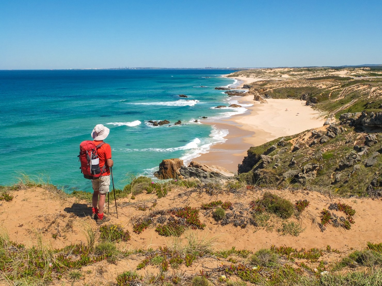
 Looking back over beautiful Praia do Malhão (Stage 4) © Cicerone Press. From Portugal’s Rota Vicentina, 2022, by Gillian Price
- What? Relatively little-known hiking trail
- Where? The south of Portugal
- Start point? Santiago do Cacém
- End point? Cabo de São Vicente
- Distance? 224km
- Completion time? Around 2 weeks
- Why this route? A stunning yet remarkably little-visited route with awesome ocean scenery
Where is the Rota Vicentina?
Starting south of Lisbon, the long-distance Rota Vicentina links Santiago do Cacém with Cabo de São Vicente, Portugal’s southwestern most point. The route traverses the Alentejo and Algarve regions, known for their beautiful and varied landscapes, including rolling hills, wooded river valleys, olive groves, cultivated fields, and the dramatic Atlantic coast. This area is ideal for walkers, offering a mix of rural charm and rugged coastal scenery. The cape of São Vicente, the last sight of land for Portuguese explorers, lends its name to the Costa Vicentina and the trek itself.
The Historical Way or the Fishermen’s Trail?
Rather than being just one route, the Rota Vicentina consists of two marked long-distance routes: the Caminho Histórico, or the Historical Way, and the Trilho dos Pescadores, or the Fishermen’s Trail. The former links Santiago do Cacém on an inland route over rolling hills to Odeceixe before moving closer to the coast the rest of the way south to Cabo de São Vicente. The shorter Fishermen’s Trail mostly sticks to breathtaking clifftops from Porto Covo down as far as Odeceixe. The Cicerone guidebook to Trekking Portugal’s Rota Vicentina uses a savvy combination of the best of both routes.
 Storks build cumbersome nests right on the cliff edge © Cicerone Press. From Portugal’s Rota Vicentina, 2022, by Gillian Price
So, is it sun and stunning views over the ocean?
Yes, but also so much more than that! The Rota Vicentina is the result of the work of the private non-profit Rota Vicentina Association, which started close to 10 years ago. It’s unusual to see a group of local family-run companies organizing such a public-use project, but they started it from scratch, choosing the trails, marking them, organizing information and promotion. The sustainability of such a special coastal area is a principal aim of the project, which is based on working cooperation between the local community and visitors.
Who is the Rota Vicentina for?
Is the Rota Vicentina the right trek for you? Well, if you…
- Enjoy dramatic cliffs, awesome ocean scenery and secluded sandy bays
- Are fascinated by gangly storks nesting on sea stacks
- Can walk around 20km per day
- Enjoy fresh fish, fruits and veg in numerous bars, cafes and seaside restaurants
- Want to explore ancient oak forests, brilliant carpets of wildflowers, sweet oranges, mouthwatering traditional Portuguese cuisine and inimitable custard tarts
…then the route through Portugal’s Rota Vicentina will quickly become one of your favorite treks!
 Stage 4 begins at the Porto Covo tourist information office © Cicerone Press. From Portugal’s Rota Vicentina, 2022, by Gillian Price
How difficult is the Rota Vicentina?
Covering level ground for the most part, the Rota Vicentina is suitable for all fit walkers and has no technical difficulties. The walking follows a string of clear paths, lanes, and country dirt roads with abundant waymarks and signposts. The odd steep section is included, but overall, it’s easy to average walking. The sun is one factor to consider as shade is at a premium. The wind should not be underestimated as this is the Atlantic coast, and spending a day being battered can be tiring, albeit exhilarating.
Is it well waymarked?
The Rota Vicentina is well-marked and checked on a regular basis by volunteers. Waymarking for the Historical Way sections consists of adjoining red/white painted stripes, which are green/blue for the Fishermen’s Trail. Where the way changes direction, so do the stripes, whereas crossed stripes mean ‘wrong way’. The markings are found on poles, rocks, tree trunks, buildings and fences. Rota Vicentina signposts supplement these with destination and distance.
How to get to the Rota Vicentina?
Portugal has excellent reliable trains and a capillary network of buses; up-to-date timetables (horários) can be consulted on company websites. The easiest way to reach the trek start, Santiago do Cacém, is on a Rede Expressos bus from Lisbon’s Terminal Rodoviário at Sete Rios. It’s a 146km/2hr journey.
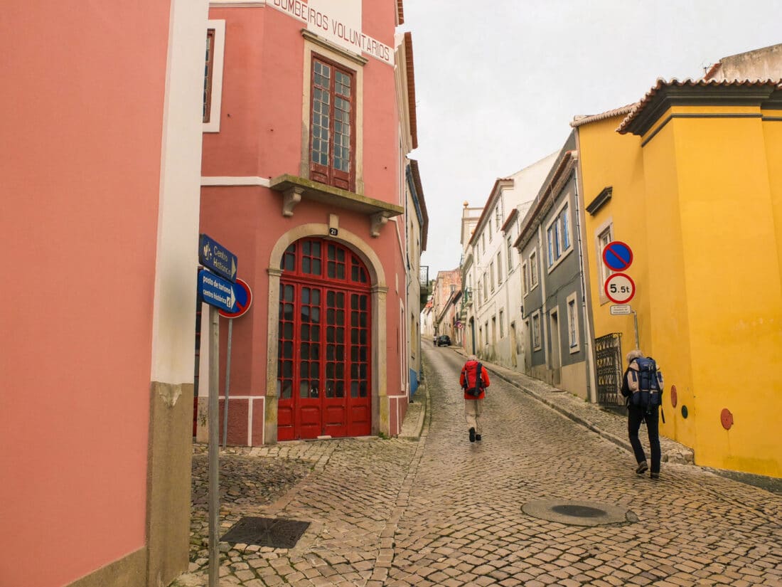 Heading up through Santiago do Cacém at the trek start (Stage 1) © Cicerone Press. From Portugal’s Rota Vicentina, 2022, by Gillian Price
When is the best time to go?
From September to June, it is feasible to walk the Rota Vicentina. The spring months of March to May/early June and then the late summer-autumn period of September to November are arguably the best times of year to walk the route. Despite cooling sea breezes, late June to August are generally stiflingly hot and not recommended as the route has a dearth of shade; the possibility of heatstroke should not be underestimated. It is best to wait until the extreme heat of the summer has abated.
The midwinter months can be mild and quite superb, albeit windy and chilly. Although temperatures don’t usually drop below 10°C at night, rainfall tends to be heaviest from December to January. The bottom line is that you shouldn’t be put off in the winter, but do wrap up warmly and take reliable rain gear.
What accommodation is available?
Walkers can find an excellent range of high-standard alojamento (accommodation) for all budgets all along the Rota Vicentina. These start with the many hostels, some known as pousada de Juventude. The next step ‘up’ is immaculately kept private rooms (quartos) known as alojamento locale, residential or hospodars. The choice continues through to mid-range hotels and boutique B&Bs in historic buildings.
Advance reservation is only usually necessary at top-end places (which may be booked ahead by agencies for groups or self-guided clients) or around public holidays.
Note – Camping is not allowed anywhere along the Fishermen’s Trail of the Rota Vicentina; it is only permitted in designated camping grounds elsewhere.
 One of the marvelous accessible beaches on the outskirts of Zambujeira do Mar (Stage 6) © Cicerone Press. From Portugal’s Rota Vicentina, 2022, by Gillian Price
What are the route highlights?
A huge chunk of this trek is in the realms of the Parque Natural do Sudoeste Alentejano e Costa Vicentina, where plant and bird life are protected. This encompasses the most extensive consolidated sand dunes in Portugal, along with stunningly rugged headlands, eroded cliffs of coloured rock, and wild beaches for swimmers and surfers alike.
What’s more, the park area guarantees that this beautiful coastline remains pristine. One of its great beauties is that it feels remote, and you can walk for hours on end without meeting anyone. Even the villages and resort towns are low-key and quiet in the low season. Naturally, as summer approaches, temperatures and prices rise as visitors pour in, but in any case, it’s too hot for walking then.
What Are the Stages of the Rota Vicentina?
The Rota Vicentina trek has 12 stages, normally walked from north to south. Each stage concludes in a hospitable village with excellent facilities. Thanks to local transport, days can vary, and walkers can easily assemble their own itineraries to suit individual holiday schedules.
The guidebook to Trekking Portugal’s Rota Vicentina uses these 12 stages:
Stage 1 – Santiago do Cacém to Moinhos do Paneiro
⦁ Distance: 21km
⦁ Time: 5hr 10min
The Rota Vicentina strikes out as the red/white-marked Historical Way leaving Santiago do Cacém to head due south on a series of clear lanes and paths. Walkers are led across rolling rural landscapes dotted with farms and through vast cork oak woods typical of the Alentejo region, with occasional promising glimpses of the coast and the sparkling Atlantic Ocean (three days off). After dropping in at a peaceful farming village, this opening stage concludes at fascinating old windmills with comfortable accommodation.
Stage 2 – Moinhos do Paneiro to Cercal do Alentejo
⦁ Distance: 20km
⦁ Time: 4hr 30min
Still as the HW, the Rota Vicentina presses on with easy-going rambling mostly on lanes through well-kept farmland in rolling countryside with cork oak woods as far as the vast expanse of the Barragem de Campilhas reservoir. Perfect for picnics and even a cooling dip, it was constructed in 1954 for irrigation purposes and usually fills up during the rainy winter months. A little further on, the day’s destination, Cercal do Alentejo, is a typical rural town with low-set whitewashed houses and good amenities.
Stage 3 – Cercal do Alentejo to Porto Covo
⦁ Distance: 16.5km
⦁ Time: 4hr 15min
Today the RV enters the vast Parque Natural do Sudoeste Alentejano e Costa Vicentina and stays in it all the way down to Cabo de São Vicente. This varied stage initially heads west through farmland, gradually dropping to the coastal plain and veering north before setting its sights on the Atlantic coast. It’s very exciting to reach the ocean and the stage conclusion at the picturesque fishing village of Porto Covo.
Stage 4 – Porto Covo to Vila Nova de Milfontes
⦁ Distance: 20km
⦁ Time: 5hr 15min
A spectacular day along the Atlantic coast with inviting beaches, dramatic cliffs, bright wildflowers, and hardy seabirds. The historic Forte da Ilha and a beachfront café await, with time for a swim. Alternating between clifftop paths and sandy inland tracks, the terrain can be tiring with little shade, so bring sun protection and water. Strong winds may make cliff edges risky. The day concludes at Vila Nova de Milfontes, a charming town on the Rio Mira estuary, where Hannibal is said to have taken shelter.
Stage 5 – Vila Nova de Milfontes to Almograve
⦁ Distance: 15km
⦁ Time: 4hr 30min
The stage begins along busy roads but can be avoided by taking a family-run boat taxi from the jetty below Vila Nova de Milfontes castle (tel: 964 200 944, daily 9am–6pm, except Dec and Jan). This charming fishing boat crosses the Rio Mira to Furnas, saving 1hr 15min of walking. The route then passes through peaceful inland farmland before returning to the coast, where you’ll find the stunning Brejo Largo beach. The day ends in the quiet town of Almograve, offering basic amenities.
Stage 6 – Almograve to Zambujeira do Mar
⦁ Distance: 22km
⦁ Time: 6hr
Another great day on the trail. The opening section as far as Cabo Sardão, approximately halfway, is especially wonderful thanks to the surprising number of stork nests on precipitous cliff edges and sea stacks, undeniably one of the top highlights of the Rota Vicentina. Afterwards comes a long rather monotonous track to a tiny, picturesque fishing harbour. All fatigue is forgotten thanks to the superb conclusion at the beautiful bay of beachfront Zambujeira do Mar.
Stage 7 – Zambujeira do Mar to Odeceixe
⦁ Distance: 18km
⦁ Time: 5hr
This stage offers varied terrain, staying close to the ocean with dramatic cliffs, inviting beaches, and several ups and downs, including some narrow, steep sections. The standout is the spectacular scenery. Midway is Azenha do Mar, a fishing hamlet with a popular seafood restaurant—arrive before midday to secure a table. The day ends in Odeceixe, a charming river town with plenty of accommodation. Located slightly inland, it marks the transition from the Alentejo to the Algarve and the end of the FT. For those doing a loop, this is where the inland route begins back toward Cercal do Alentejo.
Stage 8 – Odeceixe to Aljezur
⦁ Distance: 19km
⦁ Time: 5hr 15min
Marked red/white as per the HW, the RV proceeds inexorably on its way south. Taking a temporary break from the dramatic coast, it traverses flatter inland countryside, touching on irrigation channels and the well-served village of Rogil. At day’s end in a fertile river valley is the attractive fortified village of Aljezur boasting the ruins of a 10th-century Moorish castle offering great views and fascinating history – it is one of the seven castles depicted on the Portuguese flag. If you’re too tired after today’s exertions, make the most of the short stage tomorrow to take time out for the castle visit.
Stage 9 – Aljezur to Arrifana
⦁ Distance: 12km
⦁ Time: 3hr
This short stage winds through scenic hilly landscapes with flowering shrubs and watercourses. It ends in seaside Arrifana, a small fishing harbor with a historic fort, a few cafés, and a surfer-friendly beach. Thanks to the short distance, the beach is easily visitable. An optional 2-hour, 7km loop via Ponta da Atalaia, a panoramic Roman site, is available for those looking to extend the day. Ultra-fit walkers can opt to skip Arrifana and continue directly to Carrapateira, a challenging 8-hour trek.
Stage 10 – Arrifana to Carrapateira
⦁ Distance: 24km
⦁ Time: 6hr
Today’s stage is lengthy and rather tiring. It begins by dropping to a beautiful wild beach before rambling across undulating farmland and through woodland on a long-winded return to a superb stretch of coast with standout beaches and an inviting settlement. A handful of refreshment and accommodation options
Stage 11 – Carrapateira to Vila do Bispo
⦁ Distance: 22km
⦁ Time: 5hr 10min
This day takes you inland over rugged terrain, following the Ribeira Carrapateira valley with multiple river crossings. Normally, stepping stones keep you dry, but after heavy rain, strong currents can be dangerous, making it necessary to take the wet-weather variant from the Vilarinha junction. This alternative is only slightly longer, with 100m of extra ascent/descent. For a shorter trek, you can stop midway in the charming village of Pedralva, where renovated guest houses, a café, and a restaurant offer a comfortable stay.
Stage 12 – Vila do Bispo to Cabo de São Vicente
⦁ Distance: 14km
⦁ Time: 3hr 30min
Cabo de São Vicente (Cape Saint Vincent) is an awe-inspiring spot to finish the marvellous Rota Vicentina trek. To get there the straightforward concluding stage of the HW takes an inland route, though it follows a lot of asphalt. However, all is not lost as the FT variant provides a more exciting experience with a ramble along the dramatic coastline and dizzy clifftops. It is the same distance. Warning: in very high winds, the variant could be dangerous, and it is best to stick with the main route. Moreover, be aware that waymarking on the later section of the variant is not quite as frequent as usual.
Inland Route
Stage 1 – Odeceixe to São Teotónio
⦁ Distance: 17km
⦁ Time: 4hr 30min
This wonderfully solitary stage sees few walkers. The ocean is quickly left behind as the HW heads essentially northeast inland via a string of river valleys and wooded ridges that are reached on steep paths. Cork oaks and eucalypts, along with scented Mediterranean shrubs and flowers, are the flavour of the day. The central section follows the Ribeira Cerrado valley, which is subject to flooding in rainy periods – if necessary, take the wet-weather variant, but be aware it is not waymarked.
Stage 2 – São Teotónio to Odemira
⦁ Distance: 19km
⦁ Time: 5hr
A relaxing, straightforward stage rambling through undulating farmland and Mediterranean woods and along the cool valleys of the São Teotónio and Mira rivers. Masses of wildflowers will delight spring walkers, as will the pleasant well-served town of Odemira with its sights.
Stage 3 – Odemira to São Luis
⦁ Distance: 25km
⦁ Time: 6hr 30min
This long stage begins through farmland, followed by a dreary stretch through heavily logged eucalyptus plantations that resemble battlefields. Thankfully, a detour to the scenic rock pools at Pego das Pias (included in the total distance) adds charm. The route then follows a lush river valley before a climb through cereal fields to a quiet agricultural village for a well-deserved break. While the terrain poses no difficulties, the length earns this stage a Grade 2 rating. Start early to fully enjoy this pleasant day.
Stage 4 – São Luis to Cercal do Alentejo
⦁ Distance: 20km
⦁ Time: 5hr
The first part of the stage follows a stunning high ridge with expansive views of inland plains, the Rio Mira, and the Atlantic coast. However, much of the terrain is dominated by eucalyptus plantations, resembling terraced mines due to ongoing logging. On the bright side, native regrowth is fast, with rock rose shrubs and lavender quickly reappearing. The second half of the stage offers a more pleasant walk through native woodland and rural landscapes, ending in the lively town of Cercal do Alentejo, which has good facilities.
15 Top Tips for Trekking Portugal’s Rota Vicentina
 Magnificent cliff scenery near Cabo Sardão (Stage 6) © Cicerone Press. From Portugal’s Rota Vicentina, 2022, by Gillian Price
- Don’t underestimate the Rota Vicentina – it’s not a stroll along the beach but a multi-day trek that covers long distances. Find time to get in decent shape before setting out on your holiday. You will appreciate the wonderful scenery better if you’re not overly tired and react better should an emergency arise.
- Avoid hiking during the hot summer months, though if you do go during this time, start early and plan for frequent breaks and cooling dips in the Atlantic.
- Distribute your stay between the coast and the inland route options, ensuring you enjoy a more diverse experience and less crowded conditions.
- Consider hiking from south to north to enjoy the sun and the predominant summer winds. This will also allow you to tackle the tougher sections with soft sand later, once you’re more “track fit.”
- Camping is not allowed anywhere along the Fishermen’s Trail of the Rota Vicentina; it is only permitted in designated camping grounds elsewhere.
- As a general rule, unless the route description specifies otherwise, don’t continue for more than a kilometer or so without seeing a waymark. Should this happen, retrace your steps to the last one and hunt around.
- Make sure to book accommodation that offers early breakfasts to start your hike before the heat sets in.
- Remember sun protection—high-factor cream and a broad-brimmed hat. There’s very little shade along the way.
- Consider using a baggage transfer service that can carry your gear from place to place, especially if you want to avoid carrying heavy loads in the heat.
- Be prepared for various terrains, including soft sand, jagged limestone, steep paths, and clifftop trails. Some sections may be challenging for those with vertigo or a fear of heights.
- After heavy rains expect to encounter waterlogged lanes and high stream levels. Take great care when fording them, as there may be a strong current. Use trekking poles to check the water level, remove your boots and watch your step.
- Enhance your self-guided walk by exploring options for guided tours and cultural events offered by locals. This supports the local community and provides you with a deeper, more authentic experience.
- Do make an effort to learn some Portuguese. Rest assured it will be appreciated. Bom dia is ‘good morning’, por favor ‘please’ and olá ‘hello’. ‘Thank you’ when spoken by a man is obrigado; for a woman, obrigada. English is widely spoken but don’t take it for granted. It’s polite to check ‘Do you speak English?’ Você fala inglês?
- Don’t rely on your mobile phone as there may not be any signal.
- Take advantage of the local markets for fresh food and enjoy the seaside restaurants and cafes along the trail. Don’t miss trying the local custard tarts, a regional specialty.
 The inimitable pastel de nata tarts go down well at any time of day © Cicerone Press. From Portugal’s Rota Vicentina, 2022, by Gillian Price
Are you inspired to hike in Portugal’s Rota Vicentina?
The Cicerone guidebook to Trekking Portugal’s Rota Vicentina provides comprehensive coverage of the 224km trail that includes both the Historical Way and the Fishermen’s Trail. The guide details the main route in 12 stages and an alternative 4-stage circular route that loops back inland. It offers clear 1:100,000 mapping, in-depth route descriptions, and GPX files for download. The guide also includes information on accommodation, local transport, and refreshments, along with practical advice on planning and preparation. A Portuguese–English glossary is provided to help understand local signs and maps, making it an essential resource for anyone planning to explore this beautiful region.
And there you have it folks. Time to start planning your next adventure. As always happy travels and we will see you on the road!
For over 50 years, Cicerone Press has been your go-to guide for exploring the great outdoors. It is the leading publisher of guidebooks for walkers, trekkers, climbers and cyclists, covering destinations in Britain, Europe, and beyond. You’ll find more inspiring articles and the full range of guidebooks on the Cicerone website.
Just a Pack was not paid to feature this article, but we DO have an affiliate program for the lovely guidebooks offered by the folks from Cicerone.
Please visit:
Our Sponsor