

The Portuguese Camino is a spectacular pilgrimage route that crosses two countries; Portugal and Spain. Most pilgrims who walk it begin in Porto but the true start of the Camino is in Lisbon. The part between Lisbon and Porto has got fewer pilgrims and offers a great experience for those who seek a solitude walk through quite rural areas and countryside.
In this post I give a detailed description of the first stage, the route from Lisbon to Vila Franca de Xira.

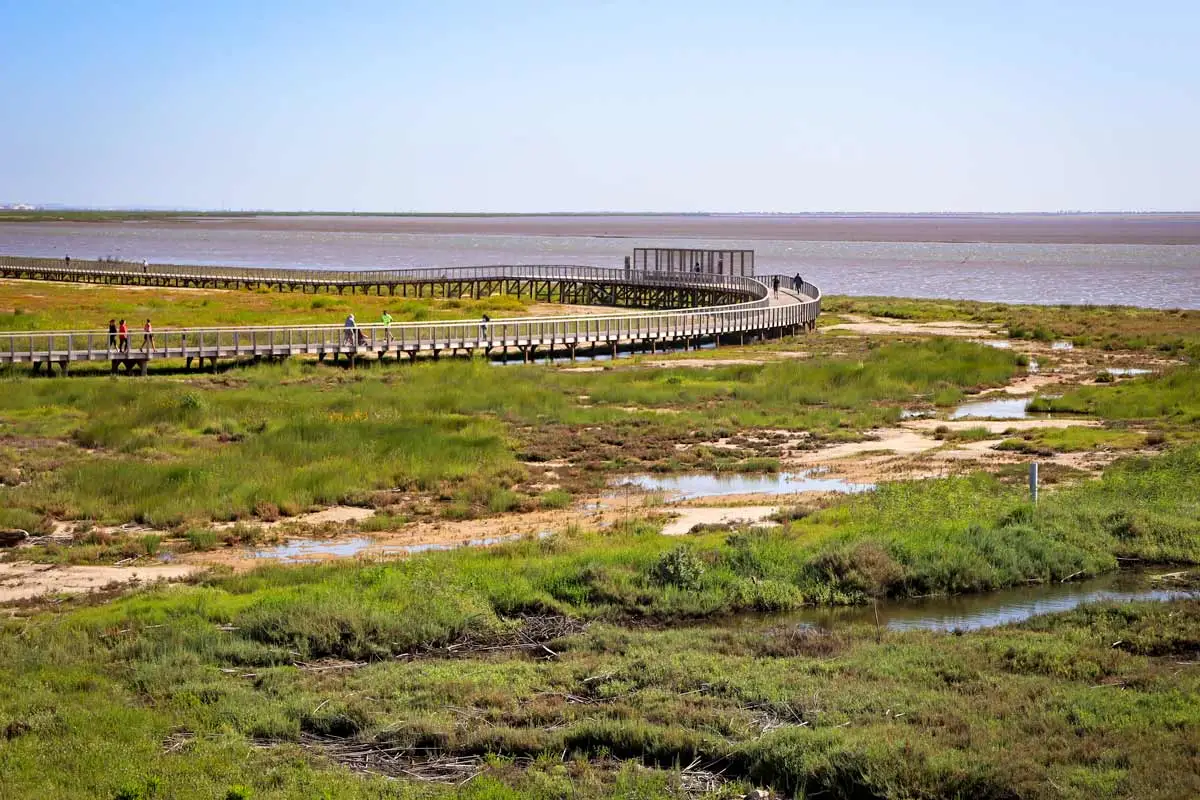 A beautiful peaceful walk on boardwalks along the Tagus River on the way from Lisbon to Vila Franca de Xira
Where in Lisbon does the Camino start?
Many people think the Portuguese Camino starts at Se Cathedral in Lisbon but in fact it starts at the Church of Santiago (Igreja de Santiago de Lisboa), 500 m from the Cathedral. The church has a big Camino sign on the facade saying that it’s the starting point of the Camino. I didn’t see any route markings. From the church you have to walk to Se Cathedral where you can find the first yellow arrow (in the bottom right of the main Facade facing the Cathedral).
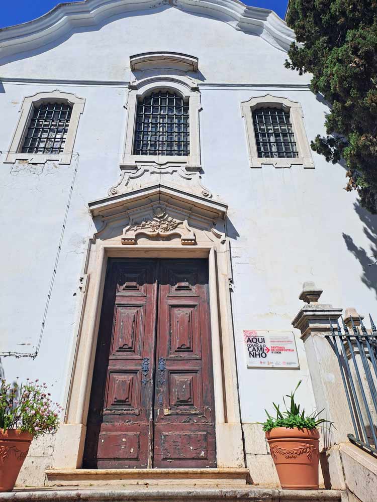
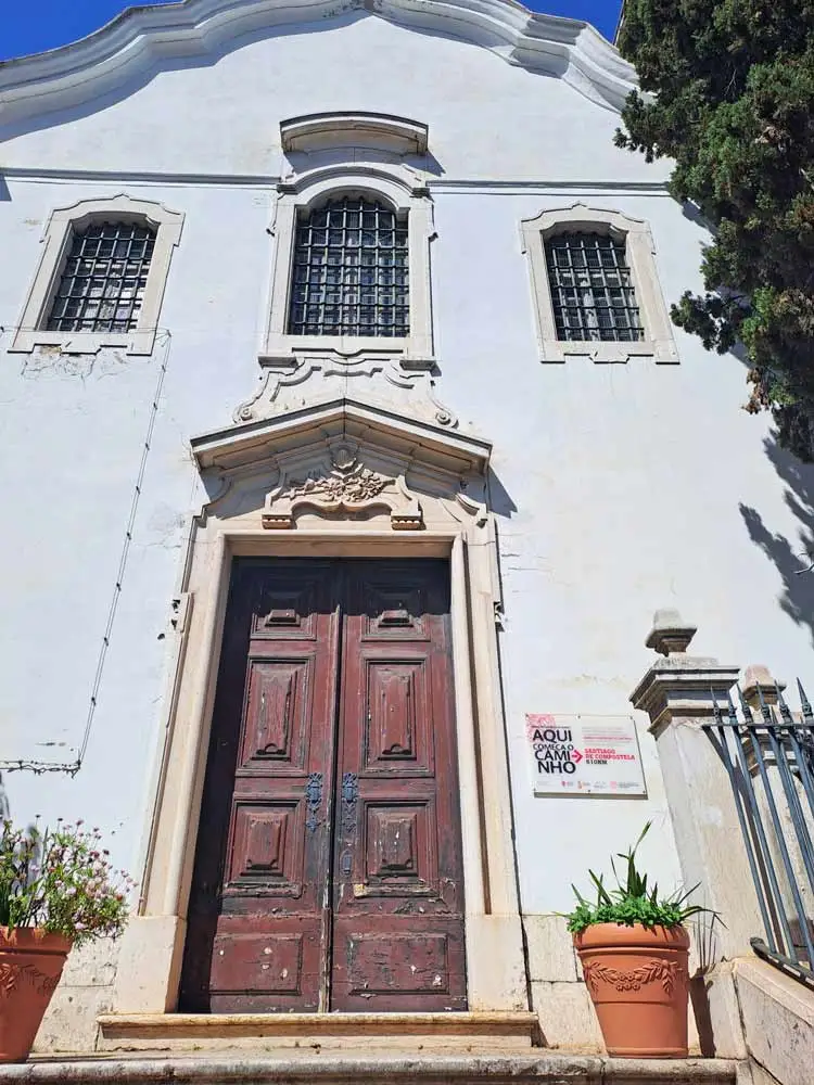 The Church of Santiago in Lisbon is a true start of the Portuguese Camino
Where to get a Credential (pilgrim’s passport) in Lisbon?
You can buy a Credential at the kiosk inside Se Cathedral in Lisbon. It costs 2 euros. You can get your first Camino stamp there too. You can find opening hours and more information here.
Is the Camino from Lisbon well-marked?
Overall the route is marked. The first part from the Church of Santiago to Parque das Nações is not marked well. There are some yellow and blue arrows but they are not very consistent.
Note that on the part of the Camino from Lisbon to Santarem you will see both yellow and blue arrows. The yellow arrow is a traditional sign on the Camino de Santiago. The blue arrows mark the Camino de Fatima, another pilgrimage route from Lisbon to the Sanctuary of Our Lady of Fatima. Both routes follow the same trail from Lisbon to Santarem where they split.

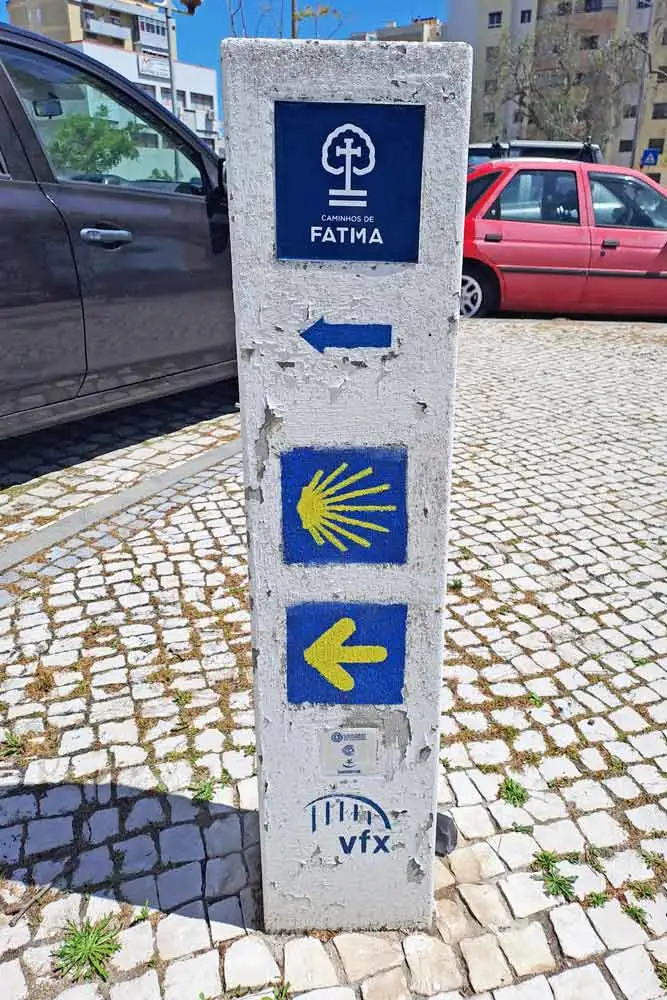 One of the route markers on the route from Lisbon. As you dan see the Camino is marked with a yellow and a blue arrow. The blue one is for the Camino Fatima
How long is the first stage from Lisbon?
The standard first stage of Portuguese Camino from Lisbon is 33 km/20.5 mi. In my opinion it’s a very long stage for the first day on the Camino. I suggest splitting it into two days. The first day you walk a short part through Lisbon from the Church of Santiago to Parque das Nações, 8 km/5 mi. On the second day you continue from Parque das Nações to Vila Franca de Xira, 25 km/15.5 mi.
Best place to stay in Lisbon before the Camino?
If you decide to split the stage into two parts then I suggest staying in Parque das Nações. It’s right on the route, you can leave your luggage at your hotel and do the first bit of the walk from the Cathedral to Parque das Nações on the first day. Stay overnight in Parque das Nações and the next day walk to Vila Franca de Xira.
Parque das Nações is a very convenient place to stay; there are plenty of restaurants, a big mall with a supermarket, and a train and bus station. It’s a 10-minute drive (3 metro stations) from the airport. The only drawback is that it is quite far from the historical center but you can get there by metro or bus.
We often stay in Parque das Nações here are some of our favorite places
- Tagus Marina (boats anchored at the marina, an interesting experience if you have never stayed on a boat before).
- Ikonik Lisboa (a 3-star hotel with a good breakfast).
- Eurostars Universal (a very nice 5-star hotel that is quite affordable during the offseason).
If you want to stay in the historical center of Lisbon, near the Cathedral here are some options
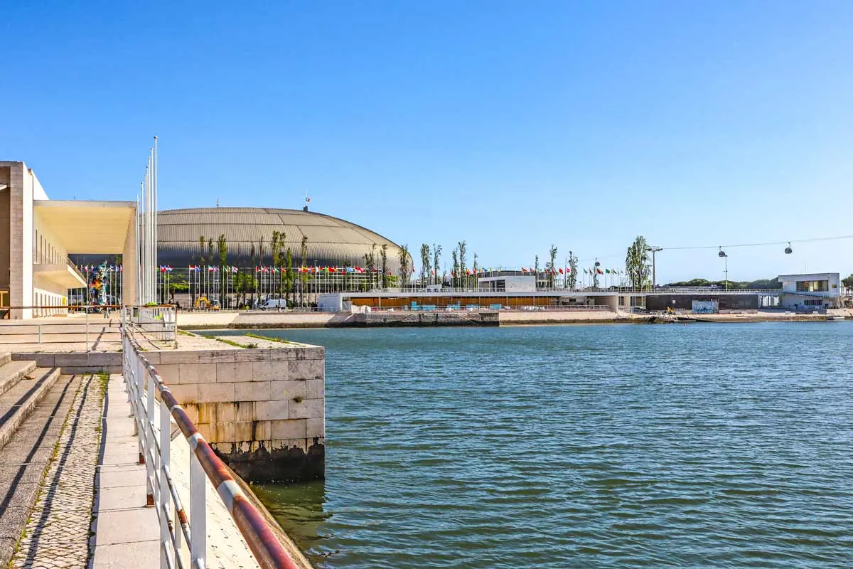 Parque das Nações on the route from Lisbon to Vila Franca de Xira, Portuguese Camino
The highlights of the stage
- The historical center of Lisbon; the Church of Santiago, Se Cathedral, narrow cobbled streets, yellow tram, etc.
- Beautiful Art Nouveau buildings at 5 km/3.1 mi just before Parque das Nações.
- Parque das Nações, a modern area of Lisbon that was built for the Expo 98.
- A walk on the promenade Passeio de Tejo.
- Walking on a long boardwalk along the Tagus River.
- A promenade in Vila Franca de Xira.
The challenges of the stage
The distance, 33 km/20.5 mi, is a big challenge if you decide to walk the entire stage in one day.
Finding the route in Lisbon is sometimes difficult due to a lack of route markings. I suggest using our GPX files for navigation.
Walking for 2 km/1.2 mi on a busy road with many cars between Alverca and Vila Franca de Xira. It was very unpleasant even though I walked it on a Saturday morning there were still many cars and trucks. For safety reasons I suggest skipping that part of the route by taking a train from Alverca to Alhandra (the next town) and continue walking from there. It’s a 4-minute train ride. The route goes through the train station in Alverca. This way you skip the dangerous part of the route.
GPX files of the route
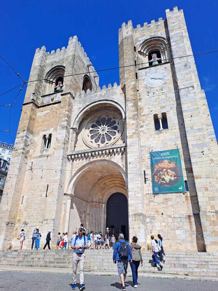
 The impressive Se Cathedral in Lisbon, one of the highlights of the stage
Lisbon to Vila Franca de Xira stage
Day 1. The Church of Santiago to Parque das Nações
- Distance – 8 km/5 mi
- Time – 2 hours
- Walking surface – 6 km/ mi – cobbled; 2 km/1.2 mi – asphalt/tar road.
- Accumulated ascent – 86 m
- Accumulated descent – 135 m
The first 2 km/1.2 mi are through the historical center of Lisbon. It’s a busy part of the city with many tourists, tactics, cafes, shops, etc. You can combine the walk with sightseeing. Sometimes it’s difficult to find the route.
2.5-3 km/1.5-1.8 mi – the port area.
3.2 km/1.9 mi – the National Museum of Tiles (Museo de Azulejos)
5.5 km/3.4 mi – two beautiful Art Nauveau buildings
6-8 km/3.7-5 mi on a promenade along the Tejo River that leads to Parque das Nações.
8 km/5 mi – Parque das Nações.
Places to stay in Parque das Nações
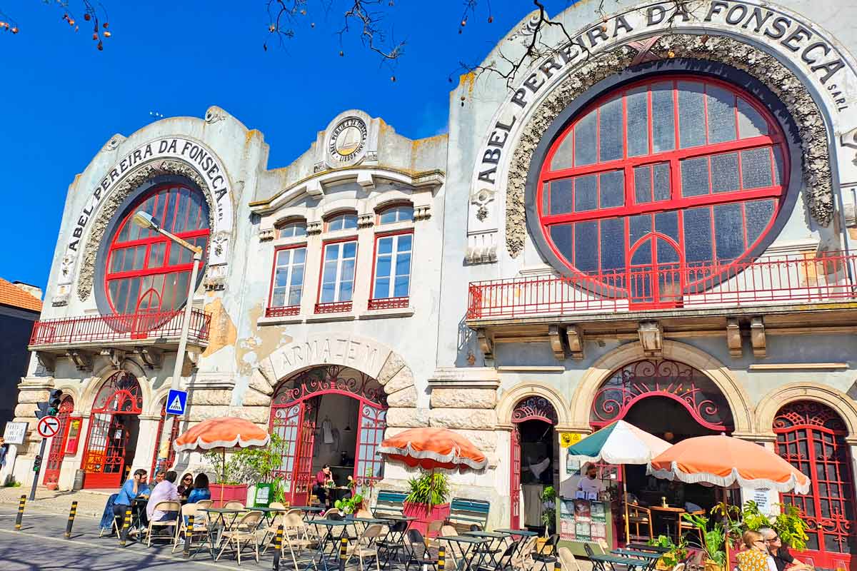 The beautiful Art-Nouveau building on the route from Lisbon to Parque das Nacoes
Day 2. Parque das Nações to Vila Franca de Xira
- Distance – 25 km/15.5 mi
- Time – 6-7 hours (moving time)
- Walking surface – 12 km/7.4 mi – asphalt/tar; 7 km/4.3 mi – boardwalk; 5 km/3.1 mi – gravel/footpath; 1 km/0.7 mi – cobbled.
- Accumulated ascent – 197 m
- Accumulated descent – 193 m
0-4 km/0-2.4 mi – the promenade Passeo de Tejo, a beautiful walk along the river.
3.3-11 km/2-6.8 mi – no places to stop for food or water. If you want to have a morning coffee or breakfast it’s better to stop somewhere in Parque das Nações.
4-11 km/2.4-6.8 mi – mostly on boardwalks along the river. A peaceful walk away from the city and roads through natural areas with many birds.
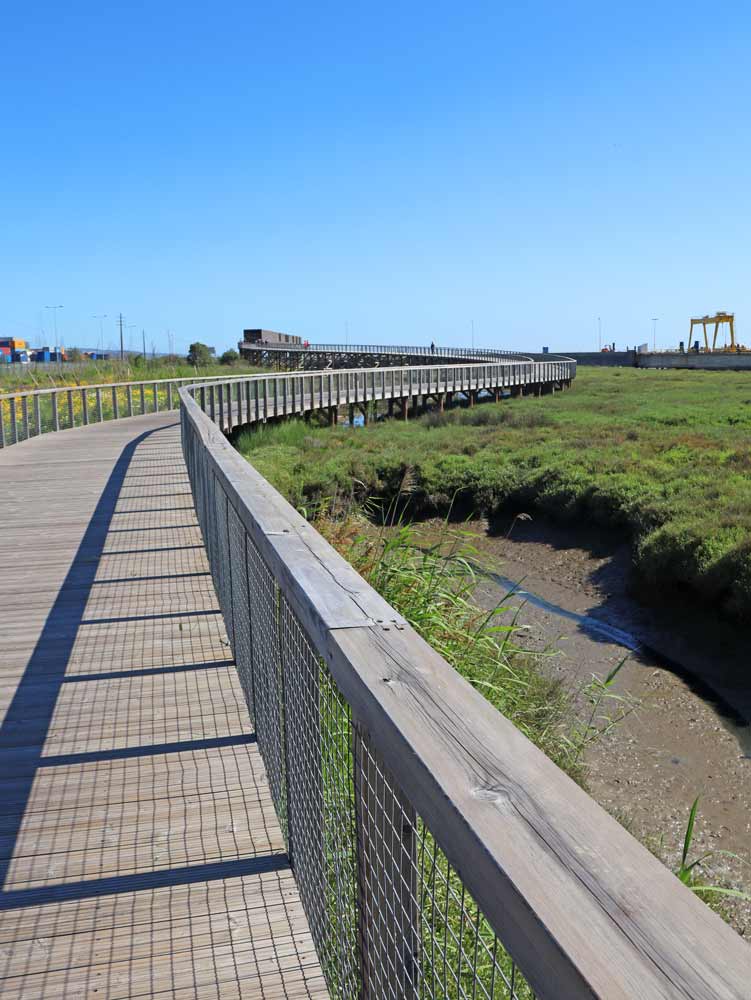 A long boardwalk from Parque das Nações to Alverca
13 km/8 mi – a cafe.
13-15.5 km/8-9.6 mi – the Camino continues mostly on boardwalks along the river and through the fields.
15.5 km/9.6 mi – the end of the boardwalk. The boardwalk goes on but there is a closed gate. It’s a restricted area
15.5-18 km/9.6-11 mi – the route goes on a footpath through the fields.
18.5 km/11.5 mi – the train station in Alverca. If you want to skip the road part of the route you can get a train to the next town Alhandra and continue walking from there.
18.5-19.5 km/11.5-12.1 mi – the Camino goes through the town.
19.5-20.5/12.1-12.7 mi – on a footpath through the fields.
20-21 km/12.4-13 mi – an industrial area.
21.3 km/13.2 mi – a supermarket.
21.3-23.5 km/13.2-14.6 mi – on a narrow shoulder of a busy road with a lot of traffic.
22.5 km/14 mi – a cafe.
23.5 km/14.6 mi – Alhandra, a small town.
24.5-25 km/15.2-15.5 mi – along a promenade in Vila Franca de Xira.
25 km/15.5 mi – Vila Franca de Xira.
Places to stay in Vila Franca de Xira


The pretty half of Stingy Nomads, responsible for all our land adventures (hiking, climbing, walking the Camino) and following them write-ups. Alya loves walking since she was a child, she prefers to walk 1000 km with a backpack rather than to do a 10 000 km road trip (actually any road trip). Alya is a big fan of Latin America, the Spanish language, and dancing. Every time we go away she desperately misses our dog Chile.
Please visit:
Our Sponsor